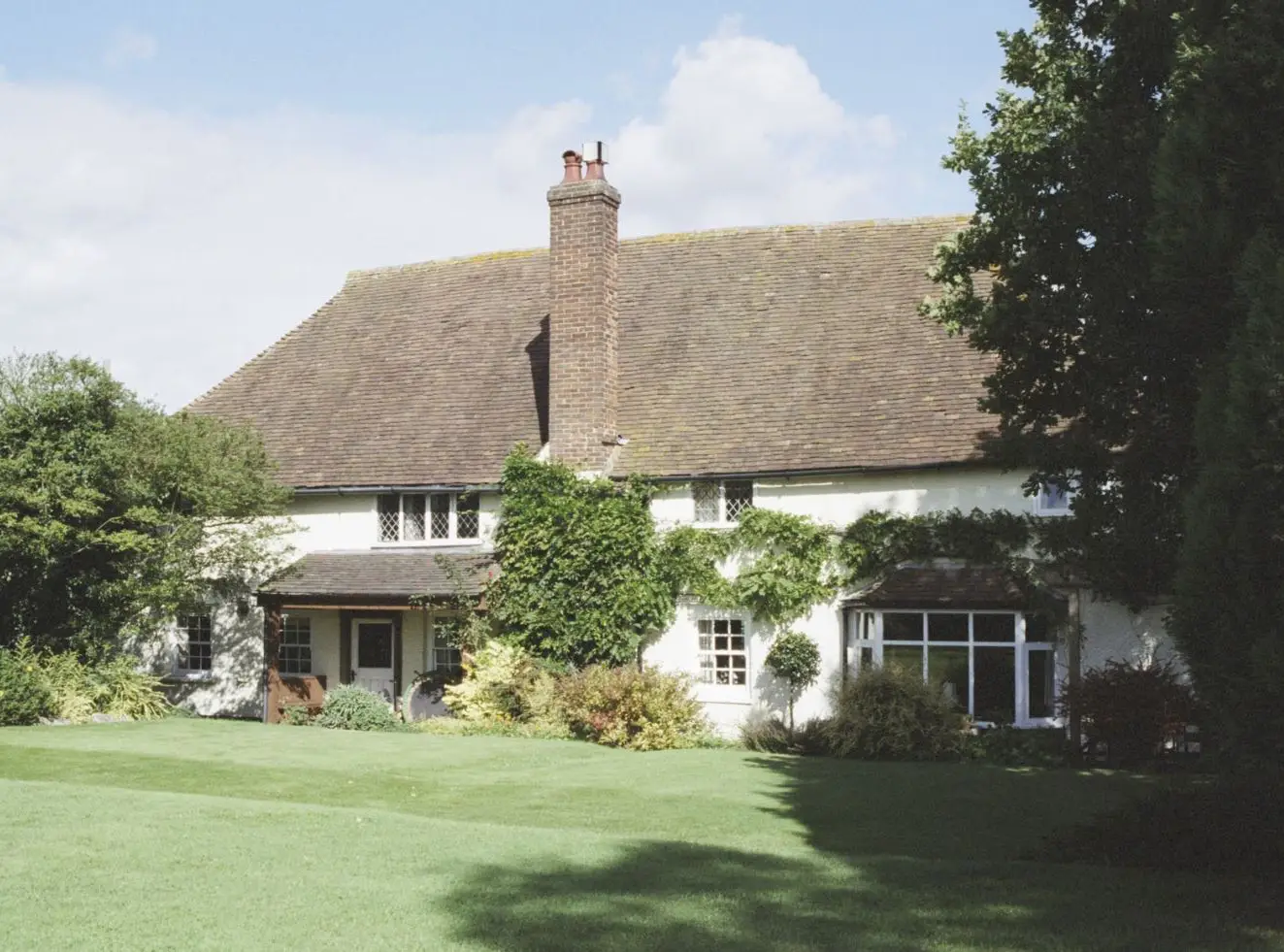
The core structure of Rumney Farmhouse dates to the early 16th century, when Queen Elizabeth I had just started her long reign. The building is timber-framed, a common architectural form during this period, as documented by its Grade II listing.
The farmhouse also underwent significant alterations in the 18th century. These changes probably involved modernising the living spaces, expanding to accommodate growing families or new agricultural functions, and maybe aesthetic modifications to the facade or interior.
The Kent Heritage website, run by Kent County Council, records Rumney Farmhouse as a post-medieval farmstead (1540 AD). “The farmhouse is detached to the side with a dispersed multi-yard. More than 50% of the original form has been lost.”
The architectural history of Rumney Farm, with its 16th-century core and later additions, echoes a recurring pattern in the development of historic farmhouses in Kent. It is physically very close to South Ash Manor, a timber-framed house nearby with stone foundations dating back to the 12th century and substantially developed in the 14th century by the Hodsoll family. Thus, whilst they were both farms more or less facing each other across South Ash Lane and their histories overlap, South Ash Manor was manorial and feudal; Rumney Farm’s 16th-century origin coincided with the rise of the yeoman class and the expansion of private land ownership. Its history is, therefore, exclusively that of agricultural activity and family life.
The following List summarises the property’s key architectural and historical milestones:
- 16th Century – original construction with a timber-framed core establishing the property as an Elizabethan farmhouse. It was called Bakers from this period to 1841.
- 18th Century – significant alterations to the building to reflect the evolution of living standards and of architectural styles.
- 1984 – Grade II Listed Building status conferred – this recognises the building’s special architectural and historic interest.
- 1998/9 – significant alterations to external elevations and internal layout. Construction of a tennis court.
16th to 18th centuries
From its outset, the building was the farmhouse of Bakers Farm. The farm and the nearby Bakers Wood seem to be named after John Baker(e) de Stanstede, who is mentioned in 1358, 1366, 1369, and 1377.
The earliest documented evidence of Baker’s farmhouse is from 1671. In the early to mid-1600s, William and Elizabeth Hodsoll lived at South Ash Manor. He died in 1663, and the estate and Manor house were inherited by their eldest son, John. It appears that Elizabeth moved to Bakers at that time, as we have her will dated 1671, in which she bequeaths “to my four daughters Ellen, Anne, Susan and Margaritt [sic] six months after my decease my house called Bakers wherein I now dwell.” This was recorded in ‘Wills and other Records relating to the Family of Hodsoll’, 1888, by James Geenstreet.
South Ash Manor is recorded as being for sale in 1723, and part of the estate included Bakers, its oasthouses and land. The extent of the land is, sadly, not described, but it is clear that hops were grown there or, at least, locally.
In the same collection by James Greenstreet, we find that in 1771 Edmund Hodsoll of St. Mary Cray left his “messuages, farm and lands called Bakers lying in Stansted” to his wife Elizabeth and their four daughters, Helena, Mary, Elizabeth and Jane.
Maybe this last legacy led to the sale of the estate, since we know that in 1792 the farm was owned by the Scudder family, with the tenant farmer being Richard Walter. The source of this information is the excellent but unpublished work by Frank Proudfoot, “A Downland Parish”.
Frank Proudfoot wrote that “In 1792, the year before his death, Richard Walters was living at Rumney Farm as a tenant of the Scudder family. He was farming in Ash some thirty-five acres, consisting of those twelve that he owned at the Billet, some land belonging to Thomas Scudder at the corner of Pease Hill and the Malthouse Road and a field at Turner’s Oak. He was also the owner of two cottages, which were at or hard by the site whereon the Royal Oak now stands. Richard Walter’s eldest son, likewise Richard, was christened at Ash, but he, more unequivocally than his father, belongs to Stansted; there he married, there he was a churchwarden, and there, in 1827, he was buried. He had taken over the Billet after his father’s time, and later lived at Rumney Farm, where he had a numerous family.”
19th century
UK farmers in the early 1800s faced severe economic and social difficulties. The end of the Napoleonic Wars in 1815 brought a sudden drop in grain prices as cheap foreign imports returned to the market. The 1815 Corn Laws, intended to protect British agriculture by restricting imports, only deepened social unrest by keeping food prices high while wages remained low. Poor harvests in the 1820s, combined with high rents, tithes and taxes, worsened rural hardship. There was also mechanisation, which reduced the need for labour. Mechanisation also required capital investment, which the old Medieval system of landowner, tenant farmer and tied farmworker was not well equipped to deal with. All this culminated in the Swing Riots of 1830 as farmers and labourers alike struggled to survive a period of rapid economic change.
Stansted was not immune to these changes. In 1831, at South Ash Manor, William Hodsoll went bankrupt and was forced to sell the house and farm, thus ending over 400 years of Hodsoll ownership. The sale included Bakers (Rumney) Farm.
Frank Proudfoot writes, “The Hodsolls continued to farm at South Ash but were no longer owners. Although the Walters were still farming at Rumney Farm, times were against them, and they increasingly turned to trades to make their living. The last Walter to farm in Ash of the family born at Rumney Farm was Henry, who was living at South Ash and farming alongside the Hodsolls. For him, as for them, the hungry 1840s proved too much and, if not in quite such distressing circumstances as they, he too made his departure. In 1867, he, or his son of the same name, was a wheelwright and builder at Stansted. His youngest son, Nimrod, was also there as a beer retailer and tax collector, two occupations that seem an odd pair at first sight.”

We do not know exactly what happened as a result of the 1831 sale, but the Tithe Schedule of 1841 shows us two things:
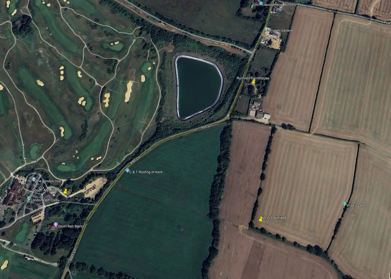
Firstly, the current site of Rumney Farmhouse (plot 390 in the survey) was called Home Field House Farm (homestead), and the owner/occupier was John Sparks. The farm comprised 80 acres, mainly on the eastern side of South Ash Road but with some land on the western side towards South Ash Manor. It was not called Bakers or Rumney Farm in the 1841 survey.
Where 1 & 2 Rumney Cottages are currently situated (on the south eastern corner of the junction of Pease Hill and South Ash Road) was an open area called Home Field (plot 394). Plot 186 was where the Anchor and Hope Pub existed for many years, but in 1841, it was described as a Homestead and Orchard near Ash. The owner/occupier was William Godwin.
Secondly, Bakers Farm was further south, situated on either side of Wises Lane, but had no Homestead. The nearest anything comes to a building is plot 412, which is recorded as a Yard and Oast for Bakers Farm. The Farm was owned by John and William Wildes (sic) and was occupied by William Hodsoll. It seems this was owned and farmed as part of South Ash Manor.
So far as Rumney Farm is concerned, we have complete census records as follows:
1841 Census – John Sparks was the farmer with his wife, Frances, his son, John and his daughter, Frances. There were also three other unrelated people living on site. Confusingly, the property was called Brumley Farm in the census return. This is the only time this name is used.
1851 Census – The farm is not named in this census. John Sparkes, 73, is a farmer of 253 acres employing 4 men and 2 boys. He was to die two years later and is buried in Stansted churchyard. His wife is Fanny, 66; his son, John, is 23 and unmarried, as is his daughter, Fanny, 27. There are 2 servants and one other person living on site.
1861 Census – The farm is called Mr Sparkes Farm, and the head of household is Fanny, aged 75, her husband having died 8 years before. The farmer is now their son John, 33, who is still unmarried and farms 200 acres. He is assisted by his unmarried sister Frances, 36. The farm must have been operating successfully, as there were two servants in the house, plus two others employed as Carters. On the grounds were two cottages; one containing a married couple and the other a family of eight. For the first time, a cottage (maybe two) is also recorded on the site on the other side of the shop and beerhouse at the Anchor and Hope. In later years, these became two cottages and changed their names along with the farm’s. It is therefore assumed that they were owned by the farm and used as tied accommodation for workers.
1871 Census – By now, the farm comprises 190 acres and is called Homefield Farm. It is still run by John, who employs nine men and one boy. His unmarried sister, Frances, is still living with John in the farmhouse, along with a servant, a farm worker, and a shepherd. There is no mention of people living in cottages in the farmhouse grounds, but there are two families living in the cottages nearer to Pease Hill (Homefield Cottages).
1881 Census – The farm, now called Home Farm, was back to 200 acres, employing four men and three boys. The unmarried brother-sister team of John and Frances was still living in the farmhouse with one maidservant. Homefield Cottages are occupied by two families whose Heads are employed as a Wagoner and an Agricultural Labourer.
1891 Census – The farm is called Sparkes Farm in the census, and the farmhouse has John, 64 and his sister Frances, 66, assisted by a young Maid Servant. Neither John nor Frances ever married, and Frances died two years later. The two cottages in the grounds reappear in this census and are occupied by two branches of the Dalley family, who were Agricultural Labourers. The cottages near Pease Hill are occupied by two farm labourer families and are called Forge Pond Cottages (there being a large pond by them and beside South Ash Road).
20th century
1901 Census – The 1901 census shows John Sparks and a housekeeper to be the only occupants of what was called Romneys Farmhouse. John was, by now, either 74 or 77 years old (the records vary) and was to die three years later, thus ending more than sixty years of the father and son/daughter Sparks family farming at the farm. There is nothing to explain the change of name of the farm, although one could speculate that with advancing years and no children, John had sold to someone else, either called Romney or with a connection to the town of that name.
The same census lists what are now 1 and 2 Rumney Cottages on the corner of Pease Hill as 1 and 2 Sparkes Cottages. They are occupied by farming families; the Head of one is a Cattle Stockman, and the Head of the other is a Teamster (someone who drives a team of horses).
1911 Census – By 1911, the Romneys Farm branch of the Sparks family had died out, and the farmhouse was occupied by Sydney and Jessie Green and a Maid Servant. Sydney described himself as a Farmer and Corn Merchant. In 1907, Sir Gerald Hohler bought Court House Farm, Stansted and at some stage incorporated Romney’s Farm into his lands. He certainly owned it in 1921 and still owned it when he died in 1934. The cottages near Pease Hill were called Romneys’ cottages and were lived in by two farming families.
1921 Census – For the first time, we have the current name, Rumney Farm. The farmhouse was occupied by John Hollands, 52 (who later bought the farm), and his wife, Alice. John was the Farm Bailiff for Sir Gerald Hohler, a position later occupied by his son John jnr, 23, who also lived there. There were also three other sons (George, Oliver and Newman) and a daughter (Alice). The detached pair of cottages, called Romney Cottages, was occupied by the Tomkin family (Jesse was a Carter for Sir Gerald) and the Eason family. George was a Cowman for John Hollands at Rumney farm.
Twelve years later, in 1933, the house was lived in by farmers John jnr (his father, John, having died in 1929) and his wife, Violet. They were farm managers to Sir Gerald and remained there for more than 30 years, bringing up their children, Norman, John, Julie and Nancy. The house was also home to William and Elsie Brown and their daughter Sheila. The Browns moved to Stansted a few years later, and Sheila still lives at Delatour, Plaxdale Green Road. Sir Gerald Hohler, the owner of Rumney Farm) died a year later in 1934, and his estate was inherited by Craven Hohler, who, himself, was killed in action aged 33 whilst flying to Egypt in 1940.
Local Historian Christophe Bull takes up the story: “On Craven Hohler’s death, Court Lodge reverted to the estate of Sir Gerald. The farm was sold in 1942, and this time Christopher Hohler bought most of it, including Court Lodge itself. Christopher became an acknowledged expert in early medieval history at the Courtauld Institute in London.
The northern part of the farm, with its house at Rumney Farm, was sold to John Hollands, who had been factor (farm manager) to Sir Gerald Hohler. Apparently, the sale went ahead on the basis that the Hohlers would have a first refusal to buy it back if Mr Holland died or moved on. In the event, John Holland sold his half in the 1960s to another local farmer – this meant that the Court Lodge Estate had been split after centuries of covering the same land.”
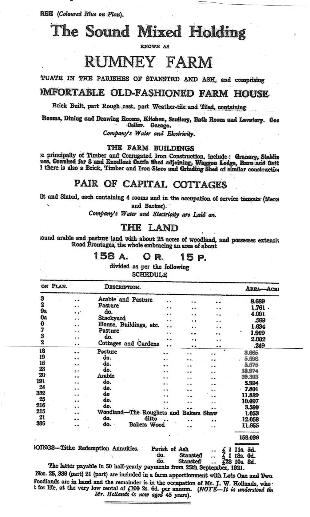
A 1942 property sale which included the farmhouse, farm buildings, two cottages, and 158 acres of land, under Lot 3:
- Court Lodge and farm
- The Old Cricket Ground
- Rumney Farm
- Berry’s Maple
- Ridgelands, Malthouse Road
The Stansted Parish Notes reveal that John Hollands gave up farming in 1969 after about 40 years at Rumney Farm. He had retired due to ill health and died in 1975. It seems that the farmland previously associated with Rumney Farm had been sold (possibly being added to the land associated with the adjacent Ash Place Farm).
The next occupants of the Farmhouse were John and Elizabeth Wood, who lived there until 1972. There followed a ten-year residency of Mr & Mrs Brown. Following the Browns were Terry and Pamela Jones, who still lived there in 2000.
The current occupants (2025) are Mr and Mrs Yusuf.