
Trosley Country Park was once part of the Trosley Towers estate. In 1887, Sir Sydney Waterlow built the Trosley Towers mansion and private drives, including Hamilton Drive, which still survives and runs from the site of the old house to Commority Road. Sir Sidney died in 1906 and passed the estate to his son Philip. When Philip died in 1931, the estate was sold off, with a Mr Shahmoon buying Trosley Towers and the surrounding woodland in 1935. He demolished the mansion in 1936 and built Hamilton Lodge and stables.
The land that now forms the park was used by the military as an Officer Cadet Training Unit (OCTU) throughout World War II, and a climbing wall, concrete lookout platform, and pumping house can still be found in the park today.
Further information on Sir Sydney Waterlow can be found under the ‘Luminaries’ page, which is part of the ‘People’ section of the website. Information on Trosley Towers and OCTU is available under the ‘Landmarks’ page.
Kent County Council bought the land and opened the 170-acre Trosley Country Park in 1976.
The park is situated on the North Downs, and the chalk grassland slopes of the park are a ‘Site of Special Scientific Interest’. The North Downs Way passes through the Country Park, via a bridleway, on its way from Wrotham to Upper Halling.
The slopes were formerly used for grazing farm animals, but were left to naturalise after the farms moved to the lower, more productive wealdland pastures. After the park was formed, these grasslands were cleared of scrub to allow the rare chalkland plants and animals to re-establish, including the musk orchid and chalkhill blue butterfly. Other meadow insects found include the dark green fritillary.
In 2004, an amenity block that includes a public toilet facility, offices, and a store area was built within the park. The new building has a sweet chestnut (Castanea sativa) timber cladding, sourced from the local trees in the park. The building features a sedum roof and a rainwater drainage system that recycles water for toilet flushing. The building also won the Public Building category of the 2005 Kent Design Awards and houses the Bluebell Cafe.
The park has various circular trails around the site, within Downs Wood, Great Wood, and Butchers Wood. The three main trails are as follows:
- The ‘Red Route’ is 2.5 miles (4.0 km) of fairly flat terrain that uses the North Downs Way.
- The ‘Yellow Route’ is a 1.5-mile (2.4 km) trail that uses parts of the Red Route but is easier and shorter.
- The ‘Blue Route’ is 2 miles (3.2 km) long and features more challenging terrain, including steep hills and climbs. It also passes Little Pell (wood), Great Pell Field (meadow).
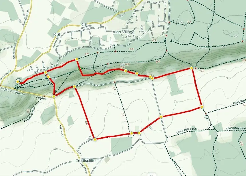
The longer Circular Walk is a 5.6-kilometre loop trail that offers opportunities to see wildlife and is primarily used for hiking, walking, trail running, and nature trips. This walk from Trosley Country Park takes in the countryside around the village of Trottiscliffe. The route is hilly and includes sections of the Pilgrims’ Way, a 120-mile-long path from Winchester to Canterbury. Encounters on the walk include steps, kissing gates and some stiles. The walk is through chalk grassland, a unique habitat home to many rare species of flora and fauna. The walk also passes the Trottiscliffe medieval church of St Peter & St Paul, which occupies an Old Saxon site that is mentioned in the Doomsday Book, completed in 1086.
Current information on the Park is available on the Kent County Council website under the leisure and community section at:
https://www.kent.gov.uk/leisure-and-community/kent-country-parks/trosley-country-park